Here is Wiltshire (County) Council's own alternative far western route, with its eastern scheme shown too.
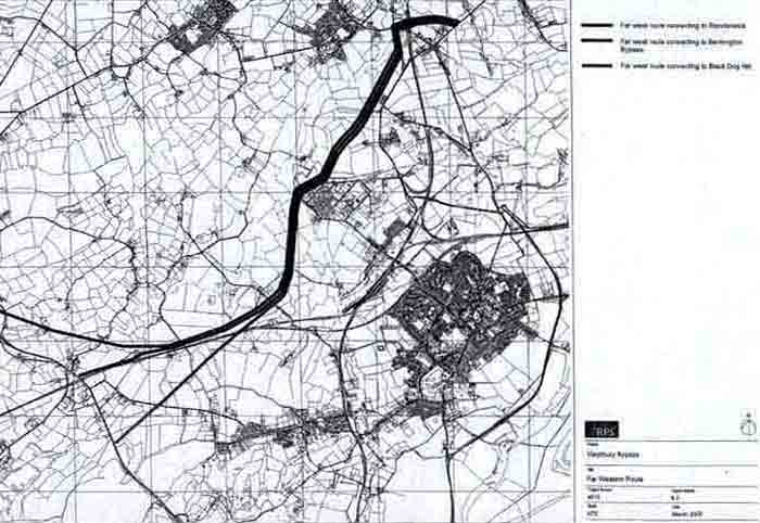
The length of the WCC far western route, as shown on this WCC drawing, includes a Yarnbrook bypass also.
But see how WCC's eastern bypass scheme would be in a long loop around Westbury to the trading estates.
For an A350 journey, the far western route is less than a third longer, though with the crucial big advantage of bypassing congested Yarnbrook. The far western route, to/from the A36, alongside the railway, would be shorter and superior for many other journeys, especially for accessing the trading estates and rail station.
Wiltshire Council's website on its eastern bypass scheme claimed that the alternative western route is longer and would cut across open ground, without saying that it was for bypassing Yarnbrook as well as Westbury. As throughout WCC's history with this scheme, it is just not comparing like with like and is very misleading.
The far western Westbury route laid out for comparison by Wiltshire Council includes a Yarnbrook bypass. This is where the worst local A350 traffic congestion is. This western route scheme was to resolve it.
An eastern bypass would actually make it a lot worse still at Yarnbrook and for other local communities.
As WCC's traffic forecasts confirm, WCC's western route could greatly reduce HGV flow past many homes.
In the 2001 WCC report, the comparative far western bypass was actually of lower estimated cost than that of the eastern bypass. The western route cost was artificially inflated by adding an extra cost for works on the A36, of about half as much again as the whole estimated cost for a far western bypass of Westbury which included a Yarnbrook and a West Ashton bypass also. The huge on-cost was explained as being for avoidance of consequent rat-running through the village of Berkley. But there are actually hardly any homes facing onto the relevant road, called Berkley Street, which is actually an original direct road into and out of Frome and consequently cannot be a so-called 'rat run'. The Berkley rat-run theory was faked.
Wiltshire Council had the truth hidden that the superior far western route is really of lower cost.
At the Inquiry, Wiltshire County Council re-presented its coincidental claimed Ł7M cost associated with A36 improvements (which when originally estimated for the 2001 report was focussed around the curious Berkley rat-running proposition) as if it was now a requirement of the Highways Agency. Subsequent enquiry with the Department for Transport and WCC established that there that was no corroboration for this claim.
Wiltshire County Council's new spin against the far western route was that 'dualling of the 7km section of existing single carriageway between Warminster Bypass and Beckington (Frome) Bypass would be justified'. However, this 7km of existing A36 is mostly improved road already. And it actually contains 1.5km of 3-lane road at Black Dog Hill. From there to the Warminster Bypass is clear road. The existing combined A36/A350 around Warminster is not dualled; it is actually single carriageway with some 3-lane overtaking sections.
The 2001 report, which is in the 2007 planning application, implies that A36 improvement is a disadvantage of a far western bypass, when it is obvious that A36 improvement would actually be of widespread benefit. Its cost should be presented separately and should not be unfairly loaded onto the far western route.
Total length of A36 which could be widened, if traffic justifies it, is just the 3km stretch at Standerwick, between the A361 Frome/Beckington bypass and the existing 3-lane section at Black Dog Hill. This would obviously be a general safety improvement, of benefit to all A36 traffic. Widening part of an existing road is hardly comparable, in cost and damage, to a new road (the eastern route) through pristine countryside.
In the context of comparison, Wiltshire County Council tried to distract focus on a Yarnbrook bypass route, because, embarrassingly, a Yarnbrook bypass is included within the alternative far western route but would be a large extra cost on top of the eastern bypass scheme. WCC did not hold with like-for-like comparison.
Build length of WCC's eastern bypass scheme, with the WWTE link, realigned roads and the new access road to the now run-down cement works, measures-out at over 7km. WCC's eastern bypass route goes through the best landscape area, through the lovely Wellhead Valley. The alternative far western route, inclusive of a Yarnbrook bypass, also measures at rather over 7km of new road to be constructed. But much of this route is by industrial estates and railway. It was independently proved at the Inquiry, without refutation, that the far western route, which goes through altogether easier terrain, would be less costly to construct.
The eastern bypass route passes close to two Sites of Special Scientific Interest, right through the middle of the Special Landscape Area and directly through and over the Wellhead Water Source Protection Zone.
The alternative/comparative western route is simply not near to any such environmentally sensitive areas.
Yet Wiltshire Council's website cheekily said that a western route would have similar environmental impacts. This muddling claim does not withstand a true comparison with the western route which follows the railway for much of its length (as the middle line on the drawing) and goes around the industrial/trading estates.
The previous overwhelming concern for avoidance of rat-running through Berkley can be contrasted with Wiltshire County Council's subsequent dropping of Yarnbrook and West Ashton from its scheme altogether. So these Wiltshire villages would get even more HGVs rumbling through them on the A350, whilst other Wilts villages in the adjacent hinterland, such as Bratton and Steeple Ashton, really would get lots of rat-running (directly by homes) because of a far worsened choke-up at the unresolved A350 bottleneck at Yarnbrook.
Back in 2001, Wiltshire (County) Council decided upon a Westbury bypass in conjunction with a Yarnbrook and West Ashton bypass - where the worst local A350 congestion is.
In 2003, WCC dumped the Yarnbrook and West Ashton part in order for the scheme to appear to be cheaper.
WCC's truncated Eastern Westbury Bypass project was the least useful portion; counter-productive in turning its back on proximity to the railway station and with potential to cause yet more HGV congestion elsewhere.
A road around the western side of Westbury will not throw extra HGV flow onto neighbouring communities.
A western route alongside the railway track, to the station, road-rail freight terminal and industrial estates, is shorter than the eastern bypass scheme. Consequently, it would be of much less cost. It would also not be expensively contending with environmental difficulties. And it would resolve many HGV problems by itself because (as another advantage over the eastern bypass scheme) it could draw off much of the HGV traffic.
A western route at Westbury would be well aligned for a subsequent Yarnbrook and West Ashton bypass. The eastern Westbury bypass route is in the wrong alignment for a Yarnbrook and West Ashton bypass (when related to Wiltshire Council's own preferred northern route around Yarnbrook and West Ashton).
The strategy approved by the South West Regional Assembly, back in 2004, was to direct long-distance north-south HGVs by other than the A350 (via the A34 etc). Wiltshire Council has still not implemented it. But this, in conjunction with a western road, of less cost and much greater usefulness, to Westbury station, railway interchange and the Westbury industrial estates, directly and economically, could work well by itself.
Wiltshire Council's repeated statement that ‘the eastern route is the only viable option’ is simply not factual. The Independent Planning Inspector who ruled against Wiltshire Council's eastern route has written that the alternative far western route would have wider benefits and would have a lower adverse impact on landscape.